Ancient Maya Structures Found in Guatemalan Jungle VOA
Pete Musto February 11, 2018
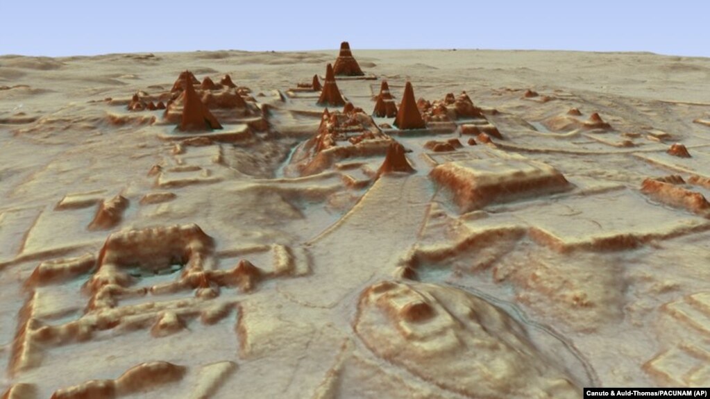 This computerized image provided by Guatemala's Maya Heritage and Nature Foundation, PACUNAM, shows a representation of the Maya archaeological site at Tikal created using LiDAR.
 Researchers using new aerial mapping technology have found thousands of never-before-detected ancient structures from the Maya civilization.
They examined from above an area of dense jungle in Guatemala’s Peten region. They discovered thousands of houses, defense works and pyramids.
They also found industrial-sized agricultural fields and canals that provided water for farms. The findings suggest that millions more people lived in the area than researchers had long believed.
A team of archaeologists from Europe, the United States and Guatemala announced their findings earlier this month. The team worked with Guatemala’s Maya Heritage and Nature Foundation.
Their study says that around 10 million people may have once lived within the area known as the “Maya Lowlands.”
“That is two to three times more than people were saying there were,” said Marello A Canuto in an interview with the Associated Press. He is an anthropology professor at Tulane University in New Orleans, Louisiana.
The researchers used a mapping method called Light Detection and Ranging, or LiDAR. A device sends laser light from high above, which hits the ground and then returns back to the device. The technology can reveal shapes and structures hidden by dense trees and plants.
The recent images revealed that the Maya changed the natural environment much more than researchers had thought. In some areas, they developed 95 percent of the available land.
Francisco Estrada-Belli is a Research Assistant Professor at Tulane University. He said the Maya’s agricultural methods were “much more intensive and therefore sustainable than we thought.”
Structures such as the extensive defensive barriers and canals suggest a highly organized workforce. Large canals even re-directed natural water flows.
The 2,100 square kilometers of mapping greatly expands the area that the Maya were known to have occupied. Their culture flourished between about 1,000 BC and 900 AD. Maya descendants still live across Central America and in parts of Mexico.
The mapping detected about 60,000 individual structures. They included four major Maya ceremonial centers with plazas and pyramids.
Thomas Garrison is an Assistant Professor of Anthropology at Ithaca College in New York. He worked on the project and is an expert on the city of El Zotz, near Guatemala’s Tikal.
He said he went to the area earlier this year with the LiDAR information to look for one of the roads that was revealed in the findings.
“I found it,” Garrison said. “But if I had not had the LiDAR and known...that’s what it was, I would have walked right over it, because of how dense the jungle is.”
Garrison said that the fields, roads and structures built by some other ancient cultures got destroyed by later generations of farming.
But in this case, the jungle grew over the abandoned Maya fields and structures. This both hid them and protected them from damage.
https://learningenglish.voanews.com/a/new-discovery-of-maya-buildings/4243559.html


